37 - 39 Oxford Street Southampton SO14 3DP Data via plota.co.uk
Proposal
Application for approval of details reserved by condition 7(Roof Terrace Lighting), 10(Extract Ventilation) and 12(Roof Terrace Louvers & Planting) of permission for change of use of an existing building from a restaurant (Use Class E(b)) to a drinking establishment and restaurant (Sui Generis) Data via plota.co.uk
Application progress
Under consideration
No decision has been issued yet. A decision is expected by 31 Jul 2026.
Documents 5
Application forms 2
Associated applications 2
Part of
Conditions 7, 10, 12 awaiting decision
- ConditionsApplication for approval of details reserved by condition 7(Roof Terrace Lighting), 10(Extract…This application26/00654/DIS
Licences at this address
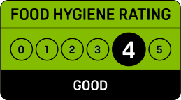
Licensed hours are what the licence permits, not opening times.
Site constraints 10
Show all 22 with distances
- 7 mRoyal Mail HouseGrade II
- 11 m31 and 32, Queen's TerraceGrade II
- 15 m30, Queen's TerraceGrade II
- 16 mThe Grapes Public HouseGrade II
- 19 mOriental Hotel Public HouseGrade II
- 27 m44, Oxford StreetGrade II
- 31 m28, Queen's TerraceGrade II
- 33 m45-47, Oxford StreetGrade II
- 36 m25,25a,26,26a,27 and 27a, Queen's TerraceGrade II
- 49 m48 and 49, Oxford StreetGrade II
- 49 mSouth Western HouseGrade II
- 50 m23 and 24, Queen's TerraceGrade II
- 61 mMain Station Building Including Booking Hall at Terminus StationGrade II*
- 80 mK6 Telephone Kiosk, Queens ParkGrade II
- 83 m17 to 24 Oxford StreetGrade II
- 104 mFormer Mercantile Marine OfficeGrade II
- 105 mUnion Castle HouseGrade II
- 112 m123-133, Bernard StreetGrade II
- 115 m113-121, Bernard StreetGrade II
- 116 mWilts and Dorset BankGrade II
- 119 m10 to 16 Oxford StreetGrade II
- 140 m61, Oxford StreetGrade II
Checked on 6 October 2026. Historic England, the Environment Agency, Natural England, the Planning Inspectorate and council datasets, Open Government Licence. A boundary can run through a site and the council holds the definitive record: confirm with the council before relying on this.
Sales history 1
Last sold for £800,000 in October 2021. Other property, freehold.
Sale prices from HM Land Registry's price paid record, matched to this application by its address.
Every application in Southampton - and every UK council - as a live feed, an API, or a bulk CSV export.
Nearby new applications
Flat 1 Gods House Winkle Street Southampton SO14 3AW
Mulberry Tree - Cut back 1 limb (includes 2 branches) by 3-4m
Telephone House 70 High Street Southampton
T1, T2, T3 and T4 Hornbeam - Reduce crown height by approximately 2m & trim side...
Park Reach 102 Chapel Road Southampton
T1 + T2 - Lime - Crown raise at all compass points to 4 meters above ground leve...
42 High Street Southampton SO14 2NS
Application for approval of details reserved by condition 2 (materials), 5 (Cons...
East End of The Royal Pier Southampton SO14 3AQ
Application for approval of details reserved by conditions 7 (Conservation Manag...
Builders Yard Travis Perkins Albert Road North Southampton
Installation of racking for external storage up to 5.5m high
Important details
- Council
- Southampton
- Application type
- Discharge of Conditions
- Postcode
- SO14 3DP
- Received
- 5 Jun 2026
- Validated
- 5 Jun 2026
- Ward
- Bargate
- Case officer
- Show
- Target decision
- 31 Jul 2026
- Applicant
- Show
- Agent
- Wildern Architecture Ltd
- Freehold owner
- Show
Public comments
No public comments yet.
Last counted 19 Oct 2026
Consultation & key dates
- Alt. reference
- 4001
- Statutory expiry
- 31 Jul 2026
- Env. assessment
- No
Historical activity at this location
27 previous applications on record - archival context, not part of the live application.
Previous applications at this address
Nearby activity

Southampton ranks #158 out of 296 councils for householder decision speed. Householder applications are slightly more likely to be approved here (93%) than the national average (90%).
Sale prices: Contains HM Land Registry data © Crown copyright and database right 2026. This data is licensed under the Open Government Licence v3.0.
Freehold owner: Information produced by HM Land Registry. © Crown copyright 2026. Source: HM Land Registry, UK and overseas companies that own property in England and Wales, September 2026 release.
Track this application
37 - 39 Oxford Street Southampton SO14 3DP
Tracking this application
Not there in a minute? Check junk - especially Hotmail and Outlook.
Go to your dashboard →Sign in to view contact details
Applicant and case-officer names are hidden from public view for privacy. Create a free Plota account - or sign back in - and we'll show them, plus you get a dashboard for alerts and tracked applications.

Check your email
Freehold owner, on paid plans
The company that owns the freehold, from HM Land Registry's register of company-owned property, with its status, business and the companies that control it from Companies House, is shown to Plota subscribers. Plans start at £49 a month.
See paid plansAlready subscribed? Sign in with the email on your plan and this page will show it.
That's today's owners
Your plan shows up to 100 freehold owners a day on the site, and more from tomorrow. For owners in bulk, the API gives them on every record on the Pro plan and above.
See API plansReferenced application
Council archive
37 - 39 Oxford Street Southampton SO14 3DP
Change of use of an existing building from a restaurant (Use Class E(b)) to a drinking establishment and restaurant (Sui Generis), with associated external alterations to the facade and the erection of a third floor with roof terrace bar (resubmission of 23/00282/FUL) (part retrospective).
- Received
- 19 Jul 2023
- Decided
- 16 Oct 2023
- Outcome
- Approved