How Plota works
The UK’s search engine for new planning applications
Plota brings new planning applications from UK council planning registers into one fast, searchable map. Instead of checking separate council websites, search by postcode, town, street, council, or a custom area you draw yourself, and see what has been submitted nearby.
We collect from councils
Plota checks council planning portals daily and brings newly published applications into one consistent search — extensions, new dwellings, change of use, listed building consent, tree works, commercial, and more.
We make it searchable
Council portals are hard to navigate without an application reference. Plota is designed around how people actually check planning and look up planning applications: search by postcode, street, town, place name, or by council — results appear on a map and in a list.
We alert you
Pick an area, choose daily, weekly, or fortnightly digests, and Plota emails you new applications as they appear. You can unsubscribe from every email.
Search & map
See applications on a fast map, not buried in a portal
Planning is local. A list is not enough.
Plota is built around a fast, responsive map that makes large volumes of planning data easy to explore. You can move around, zoom in, zoom out, and search without waiting for a council portal to reload or a long results table to catch up.
Even when there are tens of thousands of applications on the map, Plota is designed to feel smooth. Clusters expand quickly as you zoom, applications appear in context, and search results update fast enough to keep you exploring.
That matters because planning questions are usually spatial:
- What is happening near my house?
- What is planned on this street?
- Are there applications around this site?
- What has changed in this village, town, or council area?
- Which applications are close enough to matter?
Each application shows the key information available from the council register, including the address, description, reference, status where available, date received, planning authority, and a link to the official council site.
Plota does not make you dig through a slow portal to understand what is happening nearby. It puts new planning applications where they belong: on a map, searchable in seconds.
You can also narrow your view by application type. Filter for new homes, extensions, change of use, listed buildings, trees, solar, and more, and combine categories to see exactly the kind of activity you care about. Filtered views update the URL too, so you can bookmark or share them.
Plota is designed around the people who live, work, and care about the places it covers. The defaults do the right thing without any setup, and deeper customisation is there if and when you want it. The simple path and the powerful path are the same product.
Search planning applications →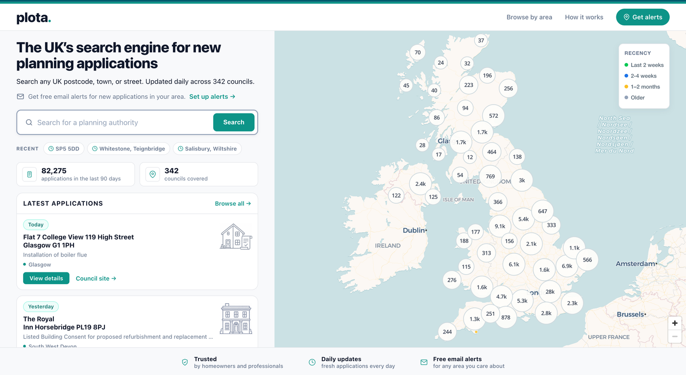

Custom alert areas
Draw an exact area, not just a rough circle
Most planning alert tools rely on a fixed radius around a postcode. Your life does not usually fit inside a perfect circle — you may want one side of a road, a conservation area, a village edge, a development site you’re monitoring, or several separate patches.
Plota lets you draw your own alert area on the map. Paint the places you care about, erase the places you do not, and save the result as an alert. For larger areas, draw a rough outline and Plota fills it for you. Whether you’re tracking planning around a single property, watching planning across a whole neighbourhood, or running site monitoring for a portfolio, the area is yours to define.
Draw an alert area →Precision under the hood
A hexagonal grid for boundaries that follow real places
Custom alert areas are stored using a hexagonal grid. Hexagons tile evenly and make it possible to define flexible boundaries. You don’t need to understand the grid — just draw the area, save it, and Plota watches it.
- Follow streets, rivers, and neighbourhood edges
- Skip areas you don’t care about
- Cover multiple separate places in one alert
- Avoid emails for applications outside your real area


Context that matters
Understand the council behind the application
Planning applications are not just about the proposal. The council handling the application matters too. Plota includes a Planning Authority Score for English councils, based on official government planning statistics — approval rate, decision time, and how often a council extends statutory time limits.
It is not a prediction for any individual application. It is context, drawn from official data, to help you understand the council behind the planning decision.
Learn about Planning Authority Scores →Who uses Plota
Built for people who need a clearer view of local planning
Residents and homeowners
See what is being proposed near your home, street, school, or village. Create an alert once, get notified when new applications appear.
Property professionals
Use Plota for site monitoring, due diligence, and planning research. Track planning applications across streets, towns, councils, or custom areas without checking multiple planning portals manually.
Builders, architects, businesses
Spot relevant applications, understand local development patterns, and watch planning activity in areas where you work or pitch.
Community groups
Monitor planning activity in places your members care about — conservation areas, village centres, or wider council areas.
Start with your area
Search a postcode, town, street, council, or place name. Plota will show new planning applications nearby and let you create an alert in seconds.
FAQ
Frequently asked questions
What does Plota show?
Plota shows new and recent planning applications collected from UK council planning registers. This can include extensions, new homes, change of use, listed building consent, tree works, commercial applications, and other planning application types.
How often is Plota updated?
Plota checks council planning portals daily. Most new applications appear after councils publish or validate them.
Can I search by postcode?
Yes. You can search by postcode, town, city, street, council, or place name.
Can I get planning alerts near my home?
Yes. You can create an email alert for a postcode, radius, council, or custom drawn area. Plota can send daily, weekly, or fortnightly digests when new applications appear.
Can I draw my own alert area?
Yes. Plota lets you draw a custom area on the map using a hexagonal grid. This is useful if you want to follow a street, village, neighbourhood, conservation area, or several separate places.
Does Plota replace the council planning portal?
No. Plota helps you find and monitor applications more easily, and holds an archive of over 10 million past applications going back to 2016. For official documents, drawings, comments, deadlines, and formal decisions on a specific application, use the council’s own planning portal.
Which councils does Plota cover?
Plota covers most UK planning authorities and is adding more over time. Coverage is shown on the site, and applications link back to the relevant council portal.
Is Plota free?
Searching, browsing, and setting up alerts are currently free.
Built from the source
Built from the source, not a black-box feed
Planning data is too important to treat as a vague feed.
Plota collects new applications from council planning registers, standardises the key details, shows them on a fast map, and links every result back to the official council record.
That means users can see where the data came from, check the original application, and understand the coverage behind the search.
Not every planning search is built this way. Some services depend on third-party datasets, partial feeds, or unclear update cycles. Plota is built around direct collection, visible source links, and daily monitoring of council registers, because planning search is only useful if the data is fresh, traceable, and clear.
What people use Plota for
Plota is used by people across the UK who want to find, check, look up, and track new planning applications. Common ways people describe what they want to do:
- find or check planning applications near me, near my home, or near my street;
- look up recent planning permission filings by postcode, town, or by council;
- track or watch new planning apps across a council area, parish, neighbourhood, or custom area;
- get planning notifications, planning alerts, weekly digests, or daily updates by email;
- monitor planning decisions and planning approvals as they appear on council registers;
- research planning around a specific address as part of property due diligence or site monitoring;
- discover householder extensions, listed building consent, tree works, advertisement consent, change of use, prior approval, or permitted development applications;
- follow planning permission across the UK nationwide, including England, Scotland, Wales, and Northern Ireland;
- use a planning intelligence tool to spot opportunities or risks in a local area;
- replace the slow process of checking many separate British council planning portals.
Plota covers UK planning, British planning, English planning, Scottish planning, Welsh planning, and Northern Irish planning — one nationwide search across the country.