6 July 2026
Application pages, rebuilt: decisions, documents, and tracking
Until now, a Plota application page gave you the essentials - the address, the proposal, the dates we held, a map - and a link to the council for everything else. Has it been decided? What's been submitted? For that, you were back in the portal.
We've rebuilt the application page. It now covers the whole application, from the day it arrives to the decision, and everything filed along the way.
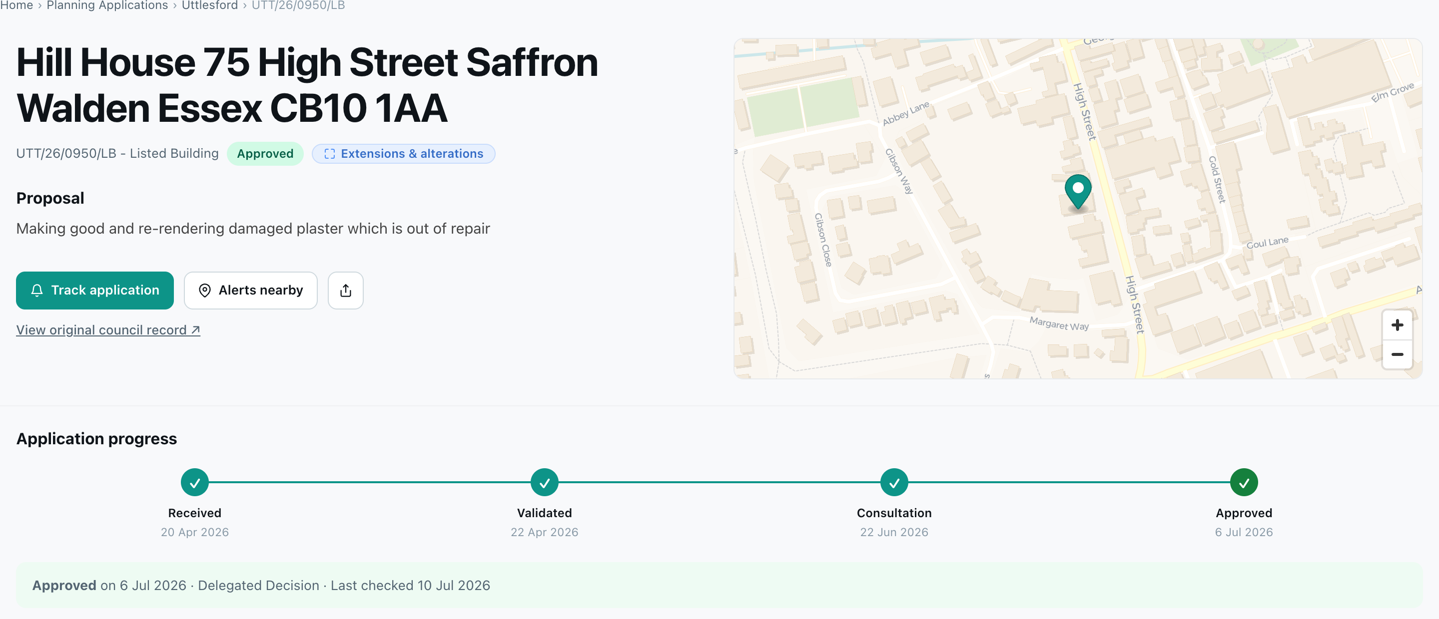
The decision, and how it got there
Each page opens with the outcome - approved, refused, withdrawn, or awaiting decision - and an Application progress timeline built from the dates on the council record: received, validated, consultation, decision. Decided applications show the decision, the date, and how it was made (delegated or committee). Refusals that go to appeal are followed too, and if an appeal is allowed the outcome updates to match.
While an application is open for comments, the page shows the deadline with a direct link to have your say before it closes.
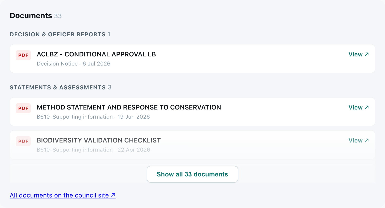
The documents
Most of the detail in a planning application sits in the paperwork. The page now lists the documents, grouped by type - decision notices and officer reports, statements and assessments, plans and drawings, application forms, and consultation responses - each linking through to the file on the council's register.
The details that used to mean a portal trip
Alongside the documents sits an Important details panel - ward, parish, case officer, target decision date, decision level, applicant, and agent - plus a Consultation & key dates panel with the consultation window and related references.

One deliberate choice: where the applicant or case officer is a named individual, the name is never published on the page. It sits behind a locked Show pill instead - signing in with a free account reveals it. Businesses and organisations show in full.
Kept current, automatically
Statuses move, documents arrive, decisions land. Plota re-checks open applications on a rolling schedule - as often as every day when a decision is due - and each page shows when it was last checked. Once decided, the page keeps the final record: the outcome, the decision notice, the full document set.
Track any application
Press Track application on any application page and Plota watches it for you. Choose what to hear about - status changes, the decision, new documents - and we email you the same day the council publishes it.
Everything you track sits in a Tracked applications tab in your My areas dashboard, next to your area alerts. There's a full guide at track a planning application.
Rolling out now
The new pages are live and rolling out council by council as each register is connected. If an application near you still shows the original page, it should gain the full version shortly. If you're a developer, the status and decision timeline behind these pages is available in the Plota API via GET /v1/applications/{id}/history.
26 June 2026
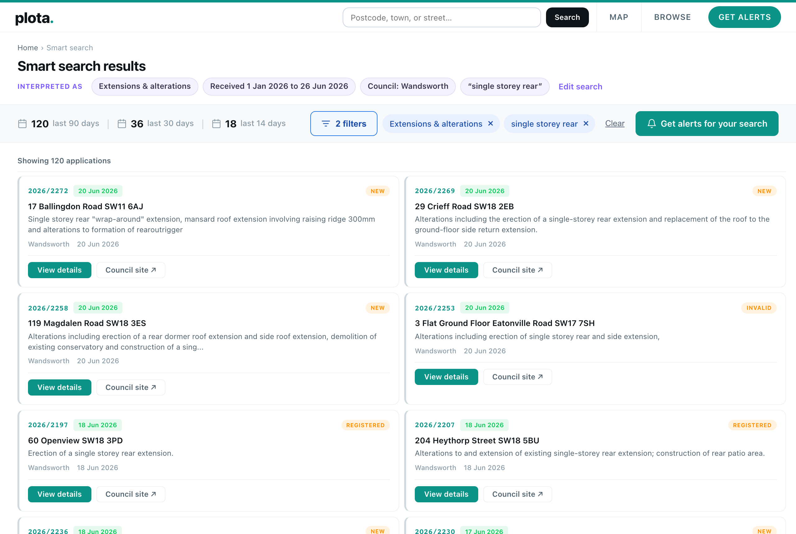
Smart search: just say what you're looking for
Planning search has always asked you to think like a database. Pick the right council, find the postcode, choose a category, set a date range, tick the boxes. If you already knew exactly where to look, it worked. If you didn't, you were stuck.
So we built smart search. Type what you want in plain English on the homepage, and Plota works out what you mean. Refused change of use to flats in Bristol this year. Loft conversions on Mare Street, Hackney. Telecoms masts in Scotland in the last three months. No filters to find, no syntax to learn - just describe it.
How it works
Plota uses a large language model to read your query and translate the messy, free-form way people describe things into our structured planning data - councils, categories, dates, status, road names, keywords. The model handles the interpretation; everything after that is Plota's own search running against real applications.
You can see exactly how it was read
The thing we cared about most was trust. A search you can't see inside is a search you can't fix. So every query is broken down into chips - one per thing we understood - shown right at the top of your results. Council, category, dates, keywords, status, road. If we got something wrong, or you want to widen or narrow it, every chip is editable and removable. Nothing happens behind your back.
What you can search for
Smart search understands the things people actually type:
- Places - a postcode, town, city, county, region, or nation. Solar farms in Essex. New homes in the South West.
- Councils - by name, including counties that map to several authorities. Barn conversions in Devon.
- Roads - say on a road and we match applications on that street; say around or near and we search a radius instead. Extensions on Lavender Hill.
- Types of work - the same categories used everywhere on Plota: extensions, new homes, change of use, listed buildings, trees, solar, telecoms masts, demolition, signs, and more.
- Specific features - things a category doesn't capture become keywords matched against the address and description. Basement. Dormer. Swimming pool. HMO. Drive-thru.
- Dates - this year, last 3 months, since March, in 2025.
- Status - approved, refused, or pending.
- Reference numbers - paste one in and we jump straight to it.
And you can combine all of it in a single sentence. Approved single storey rear extensions in Wandsworth this year sets a status, a category, a keyword, a council, and a date range at once.
The rest of Plota, unchanged
Underneath, smart search lands you on the same results pages you already know - the same map, the same list, the same filter chips you can keep adjusting by hand. And the same Get alerts button, so any search you like can become a daily, weekly, or fortnightly email.
It's live on the homepage now, and on its own page at plota.co.uk/smart-search - and it's something we'll keep developing over time. If a search ever reads wrong, the chips show you exactly how it was understood, and you can fix it in a click.
Try smart search →
12 June 2026
The Plota planning applications API
People kept asking the same question: can I get this data into my own tools? Property platforms wanting a planning layer, agencies feeding leads into a CRM, analysts pulling records into a spreadsheet, builders of AI property tools wanting structured input. So we've opened up the data that powers Plota as a proper REST API.
One endpoint, a key in the header, and you get clean, structured planning records back as JSON or CSV. Every field is normalised the same way across every council, and every record links back to the official source.
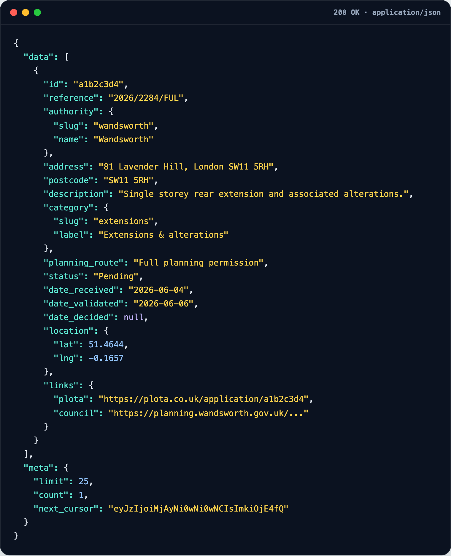
What it does
- Search applications by postcode, place, council, nation, date range, keyword, category, and status - cursor-paginated, as JSON or CSV.
- Retrieve a full record - reference, authority, address, description, category, planning route, dates, status, coordinates, Plota URL, and council source URL.
- Nearby search - find applications around a coordinate or postcode within a radius, ordered by distance.
- List councils and categories so you can build your own filters.
- Saved alert feeds - turn any alert you've set up on Plota into a reusable API feed and read its current matches.
The same normalised data sits behind all of it - one shape for every authority, so you don't have to special-case each council the way the raw portals would force you to.
Try it without signing up
There's a public demo endpoint you can hit right now with no key, and a free demo key is a couple of clicks away for full access. Full parameters, error codes, and an OpenAPI schema are in the developer docs.
Have a look at the API page for examples, pricing, and a key.
26 May 2026
Full UK council coverage
A quick but big one. Plota now monitors 392 planning authorities across all four UK nations - England, Scotland, Wales, and Northern Ireland.
Getting here was the slow, unglamorous part of the job. Every council publishes its planning register differently - different software, different layouts, different quirks - and each one had to be checked, mapped, and verified individually before we'd switch it on. We held back any authority we couldn't collect cleanly rather than show you half a picture.
What it means for you: wherever you are in the UK, you can now search, browse the map, and set up alerts for your area. If you'd tried Plota before and your council wasn't there yet, it almost certainly is now.
6 May 2026
A new home for your alerts
If you'd set up alerts on Plota before today, you managed them on a simple list page. It worked, but it wasn't great. You couldn't see what had changed, you couldn't browse the applications matching an alert without leaving the page, and on mobile it felt cramped. We've rebuilt the whole thing.
Meet the new My areas dashboard. One screen for every alert you've set up, with three tabs per alert - Overview, Applications, and Settings - and a sidebar that lets you switch between them in a click. Access it from the Manage your alerts link in any digest email - you need a signed-in session, so the URL on its own isn't enough.
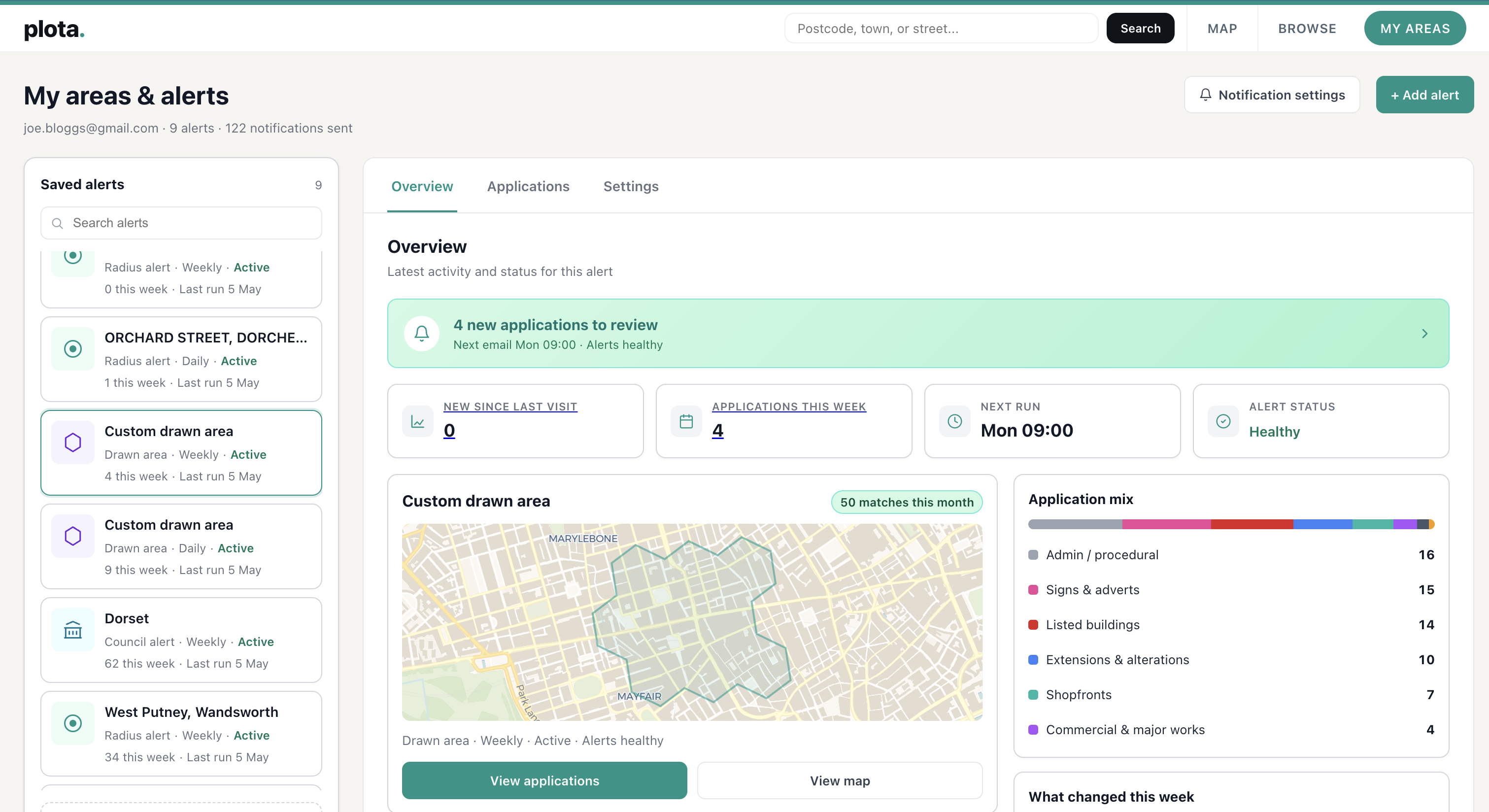
Overview: see what's happening at a glance
The Overview tab is the new front door. Across the top you get the numbers that matter - new applications since your last visit, applications this week, when the next email is going out, and the alert's overall health status.
Below that, a map of your alert area, a What changed this week breakdown by category, and an Application mix view showing the share of new homes, extensions, listed buildings, trees, and so on. Click any of those rows and you jump straight to the matching applications.
Applications: filter, sort, and see them on the map
The Applications tab is where you actually browse what's been picked up. A full table on the left with sortable columns, a side map on the right showing where each application sits inside your alert area, and a Filter button that opens up the same 15 categories used everywhere else on Plota.
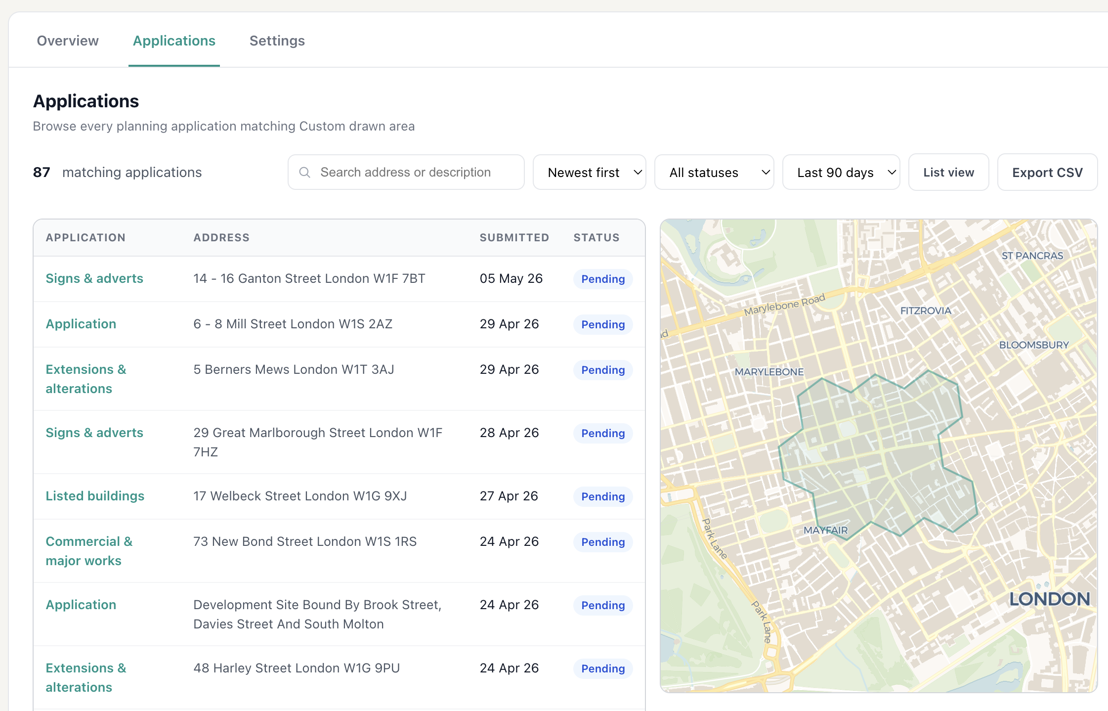
Search by address, sort by date, switch between split and list view, and export the filtered set as a CSV - useful if you want to share what's been happening with a neighbour or a planning consultant.
Settings
The Settings tab manages everything about the alert itself - frequency, day, time, area, tree filter, name.
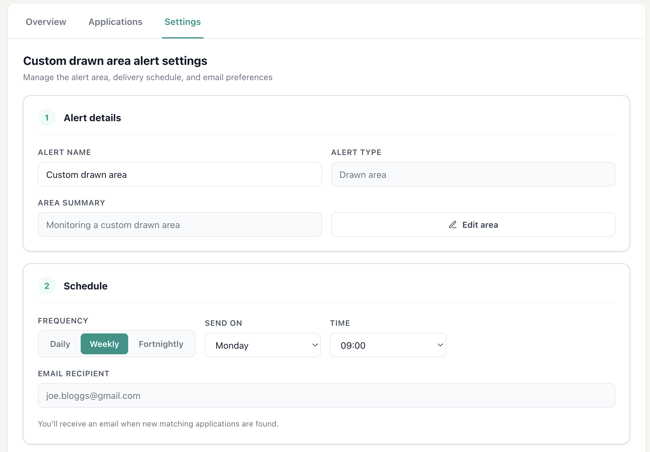
Pause an alert if you're going on holiday, change the day or time it lands in your inbox, switch to fortnightly digests, or duplicate an alert as a starting point for a new one. Editing the area itself - whether it's a postcode radius, a council, or a custom drawn boundary - is one click away.
Behind the scenes
A few less-visible improvements shipped at the same time. Page-to-page navigation inside the dashboard is now a single-page app, so clicking between tabs doesn't reload anything or jump the scroll. And every email's CTA now lands you on a pre-filtered Applications tab showing exactly the apps that were in your inbox, with pins on the map for each one.
It's at /my-areas from any link or email - the old /manage URL still works and forwards you over.
5 May 2026
Filter applications by type
You can now filter planning applications by what they actually are. New homes, extensions, change of use, commercial and major works, listed buildings, trees and landscaping, solar and renewables, telecoms masts, demolition, agricultural, signs and adverts, community, utility infrastructure, and shopfronts. Fourteen categories in total.
It sounds like a simple feature. Or at least, it does until you try to get it to a standard you're happy with.
Council planning data is unstandardised. Every authority writes application descriptions differently, with different abbreviations, formatting, and conventions. A single application can cover several types at once, like a demolition combined with a new build, or a change of use bundled with an extension. On top of that, councils log thousands of administrative notices, procedural updates, and document submissions that look like applications but aren't really what people are searching for.
We started somewhere around 90% accuracy and refused to ship. Every additional percentage point was a challenge. Borderline applications, mixed-type proposals, ambiguous wording, council-specific quirks. We rebuilt the system several times before we were happy with it.
Today we're at over 99% accuracy across our full database of new applications. The small number that don't get a category are usually council-side issues, like an entry with no description, or a procedural notice that genuinely isn't an application. We'd rather take longer to get it right than launch something that quietly hides applications you'd want to see.
To measure that, we test the classifier against a sample of 500 applications that we've categorised by hand. Each one is read and labelled manually, then compared against what the classifier produced, so the accuracy figure is grounded in a real human-graded benchmark rather than an estimate. We re-run the test as we make changes, which is how we keep it above 99%.
Powerful, but friendly
On the homepage, tap the type pill before you search to narrow your results from the start. On any council, town, postcode, or search page, tap Filter to choose one or more categories and the map and list update instantly.
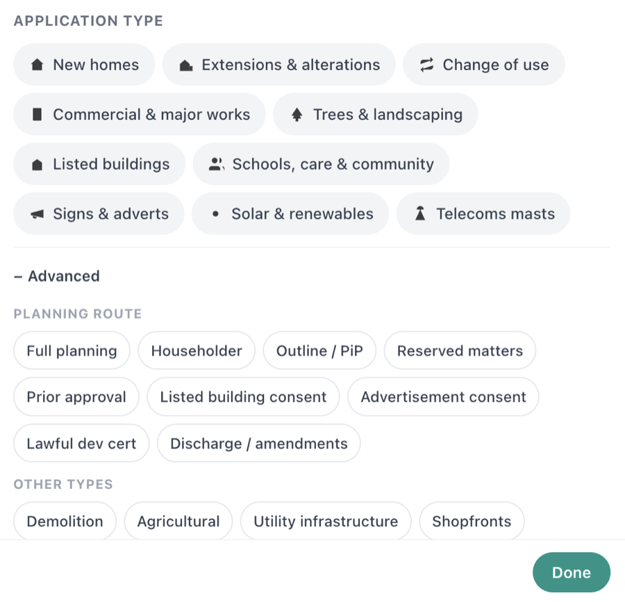
Active filters show as chips next to the button so you always know what you're looking at, and the URL updates too, so you can bookmark or share a filtered view.

It plugs into alerts as well. If you only want new homes inside your drawn boundary, or just listed building consents in a town you care about, that's now one tap away.
19 April 2026
Planning Authority Score
Every application page now shows a Planning Authority Score for the council handling it. It's a single number out of 10 that tells you how the council actually performs - not what they claim, but what the government data shows.
The score is calculated from the most recent MHCLG PS2 dataset, which covers every English local planning authority. We rank each council on three factors:
- Approval rate - what percentage of householder applications get approved
- Decision speed - what percentage are decided within the statutory 8 weeks
- Time extensions - how often the council extends the deadline beyond the standard time limit
Below the score, you'll see a plain-English summary of what to expect. Here's Fareham - one of the top-performing councils in England:

And here's Wiltshire, which scores significantly lower. The council extends the time limit on 56% of applications - one of the highest rates in England:

Each scorecard includes sparkline trends across four quarters, national average comparisons, and breakdowns for householder, minor dwellings, major dwellings, and change of use applications.
2 April 2026
Draw your own alert area
Most planning alert services give you a postcode and a fixed radius. That works if your life fits neatly inside a circle, but it usually doesn't. You might want to watch a specific neighbourhood, one side of a road, or two separate areas at once.
Plota lets you draw your exact area on the map. Paint the hexagons you care about, skip the ones you don't, and we'll email you when new planning applications appear inside your boundary.

How it works
Search for a place or zoom into the map, then click Draw area. You'll see a grid of hexagons overlaid on the map. Click or drag to paint them, use the eraser to remove any you don't want, and hit Done when you're happy.

Need to cover a bigger area? Zoom out and use scribble mode - draw a rough outline and we'll fill it with hexagons automatically. You can even draw multiple separate areas in a single alert.

Once you're done, enter your email and choose daily, weekly, or fortnightly alerts. You'll see a preview of your area and can edit it any time from the My Areas page.

Why hexagons?
Your drawn area is stored as a set of H3 hexagonal cells - the same spatial grid system used by Uber for surge pricing and Meta for location features. Hexagons tile uniformly (unlike squares, which distort at different latitudes), so your boundary is precise and consistent everywhere in the UK.
March 2026
Daily and weekly email alerts
Set up an alert for any area and we'll send you a digest of new planning applications, daily, weekly, or fortnightly. Each email includes the application reference, address, description, and a direct link to the full details on Plota or the council's own portal.
You can filter out tree applications if you only care about building work, and manage all your alerts from one page. One-click unsubscribe in every email.
Frequently asked questions
Can I track an individual planning application?
Yes. Press Track application on any application page and Plota will email you when it changes - you choose whether to hear about status changes, the decision, or new documents. Everything you track is managed from the Tracked applications tab in your My areas dashboard.
Does Plota show planning application decisions and documents?
Yes. Application pages show the outcome, a progress timeline from received to decision, key dates including the comment deadline, and the application's documents grouped by type - decision notices, officer reports, plans and drawings, statements, and forms - each linking to the file on the council register. Pages are re-checked automatically so decisions and new documents appear shortly after the council publishes them.
Can I filter planning applications by type?
Yes. You can filter by 15 categories - new homes, extensions, change of use, listed buildings, trees and landscaping, solar and renewables, admin / procedural, and more. Use the type pill on the homepage or the Filter button on any results page. Combine multiple types and the map and list update instantly. Your selection is saved in the URL so you can bookmark or share filtered views.
What is the Planning Authority Score?
A rating out of 10 for each English council, calculated from official MHCLG government data. It combines approval rate, decision speed, and how often the council extends the statutory time limit. A high score means the council is fast, approves most applications, and rarely extends deadlines.
How does the draw area feature work?
Search for a location, click Draw area, then click or drag to paint hexagons on the map. Use the eraser to remove any you don't want. Hit Done, enter your email, and we'll send you alerts when new planning applications appear inside your boundary.
Why does Plota use hexagons instead of circles?
Hexagons tile uniformly without gaps or overlaps, unlike circles or squares. Plota uses the H3 hexagonal grid system (developed by Uber) to give you precise, flexible alert boundaries that can follow roads, rivers, and neighbourhood edges - not just a fixed radius around a postcode.
How many councils does Plota cover?
392 planning authorities across England, Scotland, Wales, and Northern Ireland. We check for new applications daily and add them to the map within hours of councils publishing them.
Is Plota free?
Yes. Searching, browsing, and setting up email alerts is completely free. You can set up to 10 alert areas per email address.