Check the planning constraints on any site
Enter an address or postcode in England, Wales or Scotland. Plota reads 39 registers (from 81 published datasets) at that point, from flood zones and listed buildings to green belt and farmland grades, shows what applies on a map, and emails you the report.
For example: 10 Downing Street, London
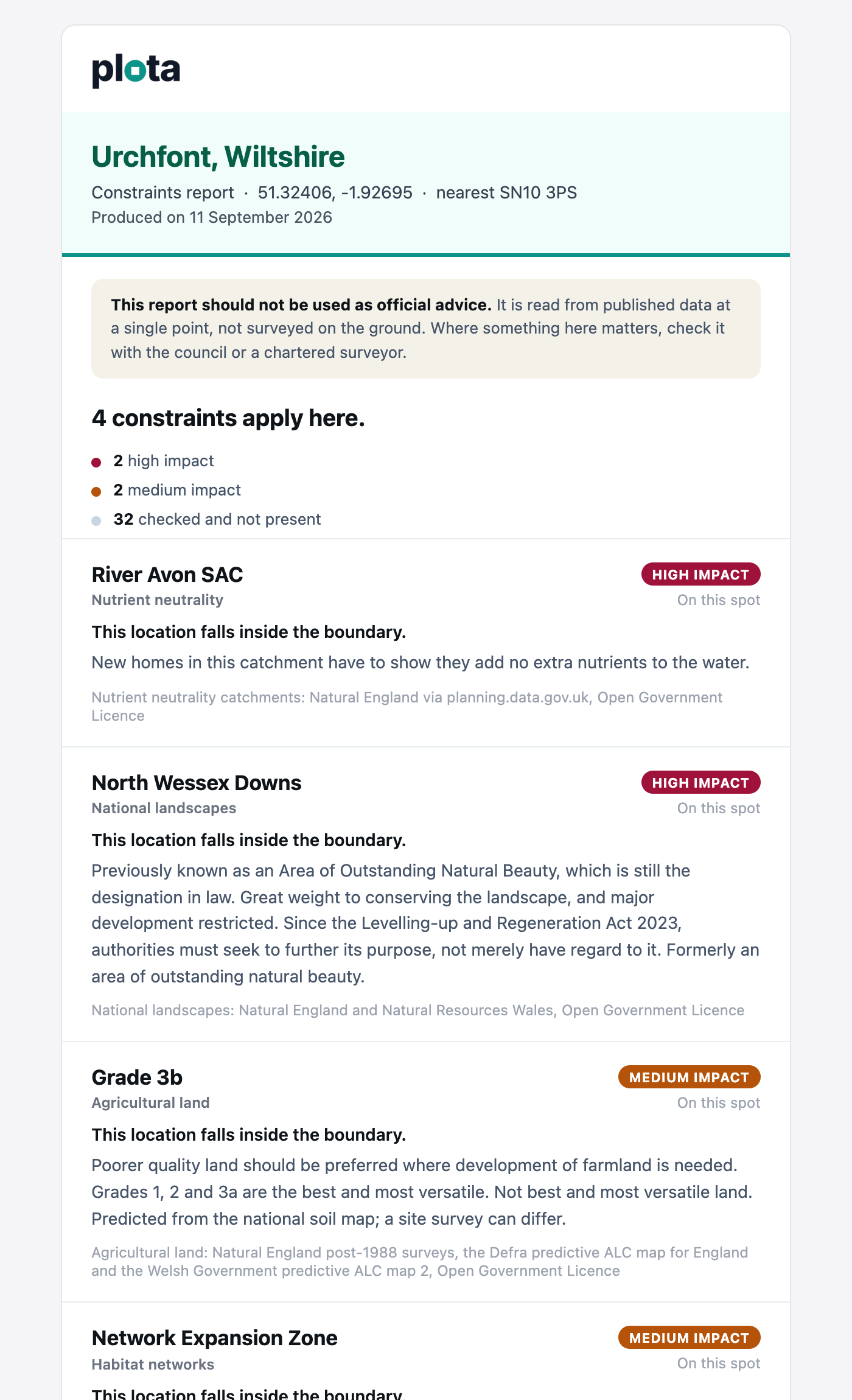
A report you can keep
Every check can be emailed to you as a report, with no account to create. It is written to be forwarded as it is, to a client, an architect or a buyer.
- Every constraint at the spot, the most significant first
- What each one asks of a planning application
- Everything that was checked and came back clear
- The source of each record, and a link that puts the pin back on the map
Check a location, press Email me report (Email me this on a phone), add your email address, and it is sent.
What is checked
The registers
- Water - flood risk zones 2 and 3, flood storage areas, nutrient neutrality catchments, and surface water flooding in Wales.
- Heritage - listed buildings, conservation areas, scheduled monuments, registered parks and gardens, archaeological priority areas and heritage at risk.
- Nature and land - green belt, national parks, national landscapes, SSSIs, protected wildlife sites, ancient woodland, tree preservation orders, article 4 areas and farmland grades.
- Access - public rights of way, national trails and open access land.
- London - Metropolitan Open Land, strategic industrial land, opportunity areas and town centres.
How to read it
Areas such as a conservation area or the green belt are checked by whether the spot sits inside them. Listed buildings, scheduled monuments and rights of way are counted when they are close by, with the distance to each.
The answer is read from published boundaries at a single point, not surveyed on the ground. Where something matters to a decision, check it with the council or a chartered surveyor.
Coverage and limits
England has the fullest set. Wales and Scotland have flood risk, listed buildings, conservation areas, SSSIs, protected wildlife sites, scheduled monuments and historic designations, and Wales also has national parks, national landscapes, ancient woodland and farmland grades. Northern Ireland is not covered yet. Layers such as conservation areas and tree preservation orders only include the councils that have published them.
This is not a local land charges search. The LLC1 and CON29 searches ordered during conveyancing are the legal record of charges, planning agreements and enforcement notices, and this check does not replace them.
Every application page with a location also carries a Site constraints section for its own site.
Why is this free?
Behind this check are 81 datasets from the Environment Agency, Historic England, Natural England, Natural Resources Wales, NatureScot, Cadw and councils across the country, which we collect, normalise into 39 layers and keep up to date, so that one point can be read against all of them at once.
We make the check free because anyone should be able to see what applies to a site before they buy it, build on it or comment on it. What we charge for is the planning intelligence around it: Plota's commercial product joins the constraints to the planning record itself, with every application checked against the same datasets overnight, alongside its decision, its timings and the other applications on the site, and delivered in a form that builds into the way your team already works.
The Plota API
Planning intelligence, built into your workflow: every application as one joined-up record, ready for the tools your team uses.
- Site constraints on every application record, so a search that returns 100 applications returns 100 constraint sets. Pro plan and above.
- Decisions, key dates, appeals and the associated applications on each site, on the same records.
- A constraints check for any coordinate or postcode, one record per point, whatever comes back.
- Connects to Reapit, Street.co.uk, CMap, Simpro and more, directly or through Zapier.