The Tickled Trout Public House Lower Road West Farleigh Kent ME15 0PE Data via plota.co.uk
Proposal
Listed Building Consent for stationing of ancillary outdoor structure (timber span marquee) on existing modern terrace (as approved under 26/502133/FULL). Data via plota.co.uk
Application progress
Approved on 5 Oct 2026 · Delegated Decision · Last checked 6 Oct 2026
Documents 8
Decision & officer reports 2
Statements & assessments 1
Consultation & comments 3
Associated applications 2
- Listed Building Consent for stationing of ancillary outdoor structure (timber span marquee) on existing modern terrace.
Licence at this address
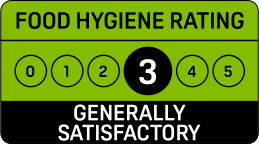
Licensed hours are what the licence permits, not opening times.
Site constraints 7
Show the other 6 with distances
- 19 mK6 Telephone Kiosk outside The Chequers Public HouseGrade II
- 41 mWall Enclosing Garden of West Farleigh HallGrade II
- 72 mWest Farleigh HallGrade I
- 108 mSmith's CroftGrade II
- 115 mGarden House, West Farleigh HallGrade II
- 116 mDoves CottageGrade II
Checked on 6 October 2026. Historic England, the Environment Agency, Natural England, the British Geological Survey and UK Health Security Agency (radon, contains BGS materials © UKRI) and council datasets, Open Government Licence. A boundary can run through a site and the council holds the definitive record: confirm with the council before relying on this.
Building
From the energy performance certificate lodged in December 2022, the latest held for this property. The building may have changed since. View the certificate
Every application in Maidstone - and every UK council - as a live feed, an API, or a bulk CSV export.
Other new applications on this street
Smiths Hall Lower Road West Farleigh Kent ME15 0PE
Conservation Area Notification: To fell row of 6no. failing Holly trees (G1), 1n...
80 Lower Road Maidstone Kent ME15 7RG
Erection of a part two storey, part single storey side extension. Renewal of per...
Lone Cottage Lower Road East Farleigh Kent ME15 0EU
Lawful Development Certificate (Existing) for basement under garage and 2 sun-pi...
1 Mays Paddock Lower Road East Farleigh Kent ME15 0JS
Submission of details pursuant to condition 6-(enhancement of biodiversity), 8-(...
Nearby new applications
Smiths Hall Lower Road West Farleigh Kent ME15 0PE
Conservation Area Notification: To fell row of 6no. failing Holly trees (G1), 1n...
Garden Cottage Ewell Lane West Farleigh Kent ME15 0NG
Demolition of existing dwelling, tractor shed and bee equipment store and erecti...
The Tickled Trout Public House Lower Road West Farleigh Kent ME15 0PE
Listed Building Consent for stationing of ancillary outdoor structure (timber sp...
The Tickled Trout Public House Lower Road West Farleigh Kent ME15 0PE
Listed Building Consent for stationing of ancillary outdoor structure (timber sp...
Important details
- Council
- Maidstone
- Application type
- Listed Building Consent
- Postcode
- ME15 0PE
- Received
- 26 Aug 2026
- Validated
- 26 Aug 2026
- Ward
- Coxheath And Farleigh
- Parish
- West Farleigh
- Case officer
- Show
- Target decision
- 21 Oct 2026
- Decision
- Application Permitted
- Decision date
- 5 Oct 2026
- Decision level
- Delegated Decision
- Applicant
- Show
- Agent
- Greenhayes Planning
How this decision compares
Decided in 40 days from validation, 16 days faster than Maidstone's median of 56 for listed building works. Approved, as 70% of listed building works here are.
Plota live figures for listed building works decided by Maidstone in the last twelve months, from validation. Maidstone decision record →
Consultation & key dates
- Alt. reference
- PP-15186997
- Planning Portal ref
- PP-15186997
- Comments by
- 1 Oct 2026
- Site or press notice
- 10 Sept 2026
- Statutory expiry
- 21 Oct 2026
- Env. assessment
- No
Historical activity at this location
21 previous applications on record - archival context, not part of the live application.
Previous applications at this address
Nearby activity

Maidstone is faster than most councils at deciding householder applications, ranking #34 out of 296. Only 30% of applications have the time limit extended, well below the 41% national average - the council usually decides on time. Householder applications are slightly more likely to be approved here (91%) than the national average (90%).
Freehold boundary: © Crown copyright and database rights 2026, HM Land Registry. Polygons © Crown copyright and database rights 2026 Ordnance Survey 100026316. Conditions of use
Energy performance: Energy performance certificates from the Energy Performance of Buildings Register, Ministry of Housing, Communities and Local Government. Contains public sector information licensed under the Open Government Licence v3.0. © Crown copyright 2026.
Track this application
The Tickled Trout Public House Lower Road West Farleigh Kent ME15 0PE
Tracking this application
Not there after a minute? Check your junk folder. It's from alerts@plota.co.uk.
Go to your dashboard →Sign in to view contact details
Applicant and case-officer names are hidden from public view for privacy. Create a free Plota account - or sign back in - and we'll show them, plus you get a dashboard for alerts and tracked applications.
