Sarvansh Global Link 29 Bridge Street Andover Hampshire SP10 1BE Data via plota.co.uk
Proposal
2 x LCD totem displays to front window Data via plota.co.uk
Application progress
Approved on 23 Jan 2026 · Delegated Decision · Last checked 5 Oct 2026
Documents 6
Decision & officer reports 2
Licence at this address
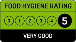
Licensed hours are what the licence permits, not opening times.
Site constraints 6
Show the other 18 with distances
- 38 mWhite Hart HotelGrade II
- 45 m6 and 6a, Bridge StreetGrade II
- 68 mNo 2 Including No 1 High StreetGrade II
- 80 mBarclay's BankGrade II
- 84 m5 Bridge StreetGrade II
- 87 m7, High StreetGrade II
- 95 m1 and 3, Bridge StreetGrade II
- 96 m2-12, Winchester StreetGrade II
- 106 m4, High StreetGrade II
- 109 mStar and Garter HotelGrade II*
- 116 mWestern HouseGrade II
- 123 mBailiff House the Mill HouseGrade II
- 129 m21, High StreetGrade II
- 132 mThe MillGrade II
- 136 mThe Globe HotelGrade II
- 137 mThe Foresters ArmsGrade II
- 148 m27, High StreetGrade II
- 149 mLloyds BankGrade II
Checked on 6 October 2026. Historic England, the Environment Agency, Natural England and council datasets, Open Government Licence. A boundary can run through a site and the council holds the definitive record: confirm with the council before relying on this.
Building
From the energy performance certificate lodged in May 2024, the latest held for this property. The building may have changed since. View the certificate
Every application in Test Valley - and every UK council - as a live feed, an API, or a bulk CSV export.
Other new applications on this street
6 And 6A Bridge Street Andover Hampshire SP10 1BH
Change of use of first floor commercial store to dwelling, subdivide second floo...
Bank House 9 Bridge Street Andover Hampshire
Change of use of the ground floor commercial unit (Use Class E) to a Bar/Drinkin...
5 The Mall Bridge Street Andover Hampshire SP10 1QL
Application for lawful development certificate for existing use as cafe/restaura...
Nearby new applications
Simply Health Group Ltd Anton House Chantry Street Andover Hampshire SP10 1DE
Application to determine if prior approval is required for a proposed installati...
6 And 6A Bridge Street Andover Hampshire SP10 1BH
Change of use of first floor commercial store to dwelling, subdivide second floo...
6 And 6A Bridge Street Andover Hampshire SP10 1BH
Internal alterations to facilitate the change of use of first floor commercial s...
26A High Street Andover Hampshire SP10 1NN
Application to determine if prior approval is required for proposed change of us...
Crown Buildings 6 - 8 London Street Andover Hampshire SP10 2PA
External alterations to building to insert 2no. windows
8 Wolversdene Road Andover Hampshire SP10 2AX
Conversion from C2 (residential institutions) to C3 (dwellinghouses) to form 2 d...
Important details
- Council
- Test Valley
- Application type
- ADVERTISEMENT - NORTH
- Postcode
- SP10 1BE
- Received
- 1 Dec 2025
- Validated
- 2 Dec 2025
- Ward
- ANDOVER WINTON
- Parish
- ANDOVER TOWN (WINTON)
- Case officer
- Show
- Target decision
- 27 Jan 2026
- Decision
- CONSENT subject to conditions and notes
- Decision date
- 23 Jan 2026
- Decision level
- Delegated Decision
- Applicant
- Show
- Agent
- LEDSynergy
How this decision compares
Decided in 52 days from validation, about the council's usual 52 days. Approved, as 100% of advertisement consent here are.
Plota live figures for advertisement consent decided by Test Valley in the last twelve months, from validation. Test Valley decision record →
Public comments
16 neighbours consulted · Last counted 5 Oct 2026
Consultation & key dates
- Alt. reference
- PP-14530082
- Planning Portal ref
- PP-14530082
- Neighbours
- 2 Dec 2025
- Consultation
- 2 Dec 2025
- Comments by
- 2 Jan 2026
- Site or press notice
- 3 Dec 2025
- Statutory expiry
- 27 Jan 2026
- Env. assessment
- No
Historical activity at this location
25 nearby applications on record - archival context, not part of the live application.
Nearby activity

Test Valley is faster than most councils at deciding householder applications, ranking #71 out of 296. Householder applications are slightly more likely to be approved here (96%) than the national average (90%).
Freehold boundary: © Crown copyright and database rights 2026, HM Land Registry. Polygons © Crown copyright and database rights 2026 Ordnance Survey 100026316. Conditions of use
Energy performance: Energy performance certificates from the Energy Performance of Buildings Register, Ministry of Housing, Communities and Local Government. Contains public sector information licensed under the Open Government Licence v3.0. © Crown copyright 2026.
Track this application
Sarvansh Global Link 29 Bridge Street Andover Hampshire SP10 1BE
Tracking this application
Not there in a minute? Check junk - especially Hotmail and Outlook.
Go to your dashboard →Sign in to view contact details
Applicant and case-officer names are hidden from public view for privacy. Create a free Plota account - or sign back in - and we'll show them, plus you get a dashboard for alerts and tracked applications.
