2 Crown Square Matlock Derbyshire DE4 3AT Data via plota.co.uk
Proposal
Alterations to shopfront entrance (part-retrospective) Data via plota.co.uk
Application progress
Refused on 9 Apr 2026 · Delegated · Last checked 10 Jul 2026
Licence at this address
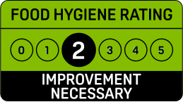
Licensed hours are what the licence permits, not opening times.
Site constraints 10
Checked on 6 October 2026. The pin for this application is the centre of its postcode rather than the building, so distances to nearby designations are measured from the postcode and can be out by the width of the postcode area. Historic England, the Environment Agency, Natural England, the British Geological Survey and UK Health Security Agency (radon, contains BGS materials © UKRI) and council datasets, Open Government Licence. A boundary can run through a site and the council holds the definitive record: confirm with the council before relying on this.
Sales history 1
Last sold for £86,000 in November 2007. Flat or maisonette, leasehold.
Sale prices from HM Land Registry's price paid record, matched to this application by its address.
Building
From the energy performance certificate lodged in March 2020, the latest held for this property, matched to this application by its address. The building may have changed since. View the certificate
Every application in Derbyshire Dales - and every UK council - as a live feed, an API, or a bulk CSV export.
Nearby new applications
37 New Street Matlock Derbyshire DE4 3FH
Loft conversion including rear facing box dormer and installation of 2no. front ...
2 Causeway Lane Matlock Derbyshire DE4 3AR
Non-material amendment - Alteration to design of combined Defibrillator and Blee...
County Hall Smedley Street Matlock Derbyshire
Reduce 1no. beech tree to a height of 3 metres and cut back low branches to 5no....
Buddys Unit A 77 Dale Road Matlock Derbyshire DE4 3LT
Erection of a single storey lean-to rear extension (retrospective)
11 New Street Matlock Derbyshire DE4 3FE
Fell to ground level 1no. Robinia and 1no. Japanese Maple
63 Lime Tree Road Matlock Derbyshire DE4 3EJ
Fell 1no. Beech Tree
Important details
- Council
- Derbyshire Dales
- Application type
- Full Planning Permission
- Postcode
- DE4 3AT
- Received
- 12 Feb 2026
- Validated
- 12 Feb 2026
- Ward
- Matlock West
- Parish
- Matlock Town
- Case officer
- Show
- Target decision
- 9 Apr 2026
- Decision
- Refused
- Decision date
- 9 Apr 2026
- Decision level
- Delegated
- Appeal
- Dismissed · 8 Jul 2026 · Written Representations · Inspectorate case 6009157 ↗
- Applicant
- Show
- Agent
- Manning Holden Architects Limited
How this decision compares
Decided in 56 days from validation, about the council's usual 56 days. Refused, as 21% of commercial premises here are.
Plota live figures for commercial premises decided by Derbyshire Dales in the last twelve months, from validation. Derbyshire Dales decision record →
Consultation & key dates
- Alt. reference
- PP-14689667
- Planning Portal ref
- PP-14689667
- Neighbours
- 19 Feb 2026
- Consultation
- 19 Feb 2026
- Comments by
- 19 Mar 2026
- Site or press notice
- 26 Feb 2026
- Statutory expiry
- 9 Apr 2026
- Env. assessment
- No
Historical activity at this location
25 nearby applications on record - archival context, not part of the live application.
Nearby activity

Derbyshire Dales ranks #121 out of 296 councils for householder decision speed. Householder applications are slightly more likely to be approved here (93%) than the national average (90%).
Sale prices: Contains HM Land Registry data © Crown copyright and database right 2026. This data is licensed under the Open Government Licence v3.0.
Energy performance: Energy performance certificates from the Energy Performance of Buildings Register, Ministry of Housing, Communities and Local Government. Contains public sector information licensed under the Open Government Licence v3.0. © Crown copyright 2026.
Track this application
2 Crown Square Matlock Derbyshire DE4 3AT
Tracking this application
Not there in a minute? Check junk - especially Hotmail and Outlook.
Go to your dashboard →Sign in to view contact details
Applicant and case-officer names are hidden from public view for privacy. Create a free Plota account - or sign back in - and we'll show them, plus you get a dashboard for alerts and tracked applications.
