Kings Head 38 London Road Sittingbourne Kent ME10 1NJ Data via plota.co.uk
Proposal
Demolition of existing toilet block and erection of a part single storey, part two storey side extension to accommodate a bistro/breakfast room, new toilet facilities, 3no. guest rooms, and manager's residential accommodation. Data via plota.co.uk
Application progress
Under consideration
No decision has been issued yet. Plota predicted a decision around 28 Oct 2026; it is now day 57.
Documents 4
Statements & assessments 3
Other documents 1
Licence at this address
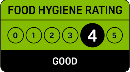
Licensed hours are what the licence permits, not opening times.
Site constraints 4
Show all 3 with distances
- 31 mWestfieldGrade II
- 52 mTannery HouseGrade II
- 67 mChalkwell HouseGrade II
Checked on 6 October 2026. Historic England, the Environment Agency, Natural England, the British Geological Survey and UK Health Security Agency (radon, contains BGS materials © UKRI) and council datasets, Open Government Licence. A boundary can run through a site and the council holds the definitive record: confirm with the council before relying on this.
Sales history 2
Last sold for £460,000 in April 2025. Other property, freehold.
More than one property is recorded at this address: HM Land Registry does not always give the flat or unit.
Sale prices from HM Land Registry's price paid record, matched to this application by its address.
Building
From the energy performance certificate lodged in March 2025, the latest held for this property. The building may have changed since. View the certificate
Every application in Swale - and every UK council - as a live feed, an API, or a bulk CSV export.
Other new applications on this street
Sutton House 5 London Road Sittingbourne Kent ME10 1NQ
Submission of details pursuant to condition 3-(Materials), 7-(archaeological fie...
Rhode House Service Station London Road Sittingbourne Kent ME10 1QB
Tree Preservation Order Application: T2 Horse Chestnut - Remove trunk and basal ...
25-29 Springfield Place London Road Sittingbourne Kent ME10 1FH
Erection of four-storey extension to front of building and new four-storey build...
161 London Road Sittingbourne Kent ME10 1PA
Submission of details pursuant to condition 5- (sustainable construction) subjec...
Nearby new applications
Sutton House 5 London Road Sittingbourne Kent ME10 1NQ
Submission of details pursuant to condition 3-(Materials), 7-(archaeological fie...
Cockleshell Walk Car Park St Michaels Road Sittingbourne Kent ME10 1AU
Submission of details pursuant to conditions 26 (external materials), 29 (window...
Marco Industries 152 Staplehurst Road Sittingbourne Kent ME10 1XS
Submission of details pursuant to Condition 6 - Contamination Investigation, in ...
152 Marco Industries Staplehurst Road Sittingbourne Kent ME10 1XS
Submission of details pursuant to Condition 11 - Construction Environmental Mana...
Marco Industries 152 Staplehurst Road Sittingbourne Kent ME10 1XS
Submission of details pursuant to Condition 10 - Foul Water Drainage in relation...
Land At Borden Lane Sittingbourne Kent
Erection of 15no. residential dwellings together with associated access point, l...
Important details
Decision outlook
Day 57, past the statutory target. 89% of demolitions in Swale are decided within thirteen weeks, which runs to 1 Dec 2026; extensions of time are common, and the council need not decide on the day. Last seen undecided on 27 Oct 2026.
Plota live figures for demolitions decided by Swale in the last twelve months, from validation. Swale decision record →
Consultation & key dates
- Alt. reference
- PP-15171801
- Planning Portal ref
- PP-15171801
- Comments by
- 6 Oct 2026
- Site or press notice
- 15 Sept 2026
- Statutory expiry
- 27 Oct 2026
- Env. assessment
- No
Historical activity at this location
13 nearby applications on record - archival context, not part of the live application.
Nearby activity

Swale is one of the slowest councils in England for householder decisions, ranking #275 out of 296. The council extends the time limit on 70% of applications - one of the highest rates in England. Expect your application to take longer than the standard deadline. Householder applications are slightly more likely to be approved here (94%) than the national average (90%).
Sale prices: Contains HM Land Registry data © Crown copyright and database right 2026. This data is licensed under the Open Government Licence v3.0.
Freehold boundary: © Crown copyright and database rights 2026, HM Land Registry. Polygons © Crown copyright and database rights 2026 Ordnance Survey 100026316. Conditions of use
Energy performance: Energy performance certificates from the Energy Performance of Buildings Register, Ministry of Housing, Communities and Local Government. Contains public sector information licensed under the Open Government Licence v3.0. © Crown copyright 2026.
Track this application
Kings Head 38 London Road Sittingbourne Kent ME10 1NJ
Tracking this application
Not there in a minute? Check junk - especially Hotmail and Outlook.
Go to your dashboard →Sign in to view contact details
Applicant and case-officer names are hidden from public view for privacy. Create a free Plota account - or sign back in - and we'll show them, plus you get a dashboard for alerts and tracked applications.

The consultation period closed on 6 Oct 2026.